Trail On foot Bad Brückenau - Rhön-Rundweg 5 Sinntal - Photo

Tous les sentiers balisés d’Europe PRO

© OpenStreetMap contributors
Length
Length
6.9 km
Max alt
Max alt
454 m
Uphill gradient
Uphill gradient
201 m
Km-Effort
Km-Effort  
9.6 km
Min alt
Min alt
271 m
Downhill gradient
Downhill gradient
201 m
Boucle
Boucle
Yes
Signpost
Signpost
Creation date :
2022-02-11 14:08:50.743
Updated on :
2022-02-11 14:08:50.743

(0 Reviews)

On foot
On foot
2h10
Difficulty : Easy

Scan this QR Code to open this trail in the SityTrail application

FREE GPS app for hiking

Logo SityTrail SityTrail

IGN / Geographical institutes

Download SityTrail from the App Store Download SityTrail from Google Play

Logo SityTrail SityTrail World

The world is yours!

Download SityTrail from the App Store Download SityTrail from Google Play Download SityTrail on Huawei AppGallery

About

Trail On foot of 6.9 km to be discovered at Bavaria, Landkreis Bad Kissingen, Bad Brückenau. This trail is proposed by SityTrail - itinéraires balisés pédestres.

Description

Symbol: Weiße 5 auf blauem Hintergrund


Website: https://www.bad-brueckenau.de/de/index.cfm?fuseaction=gaeste&rubrik=wandern#/de/bad-brueckenau/default/detail/Tour/B4ED78C972E20D629054F29D3ED68C6F/fondsbergweg-5

Photos

Positioning

Country:
Germany
Region :
Bavaria
Department/Province :
Landkreis Bad Kissingen
Municipality :
Bad Brückenau
Location:
Unknown
Start:(UTM)
553160 ; 5572680 (32U) N.

Trails nearby

Trail On foot Sinntal - Oberzell - Rundwanderweg Hemmersbach - Photo
On foot
PRO

On foot

Easy
Sinntal, Hesse, Main-Kinzig-Kreis, Germany
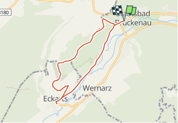
7.8 km | 9.8 km-effort
2h 14min
Yes
Trail On foot Sinntal - Spessartspuren - Schwarzenfelser Sonnenseite - Photo
On foot
PRO

On foot

Easy
Sinntal, Hesse, Main-Kinzig-Kreis, Germany
5.8 km | 7.3 km-effort
1h 39min
Yes
Trail On foot Sinntal - Oberzell - Rundwanderweg Sandberg - Photo
On foot
PRO

On foot

Easy
Sinntal, Hesse, Main-Kinzig-Kreis, Germany
4.3 km | 6.3 km-effort
1h 26min
Yes
Trail On foot Sinntal - Oberzell - Rundwanderweg Sinngrund - Photo
On foot
PRO

On foot

Easy
Sinntal, Hesse, Main-Kinzig-Kreis, Germany
5.3 km | 6.2 km-effort
1h 25min
Yes
Trail On foot Sinntal - Oberzell - Rundwanderweg Haag - Photo
On foot
PRO

On foot

Easy
Sinntal, Hesse, Main-Kinzig-Kreis, Germany
8 km | 10.8 km-effort
2h 27min
Yes
Trail On foot Sinntal - Ulrich von Hutten Pfad - Photo
On foot
PRO

On foot

Easy
Sinntal, Hesse, Main-Kinzig-Kreis, Germany
6.4 km | 8.2 km-effort
1h 52min
No
Trail On foot Sinntal - Oberzell - Rundwanderweg Hirschberg - Photo
On foot
PRO

On foot

Easy
Sinntal, Hesse, Main-Kinzig-Kreis, Germany
4.7 km | 6.3 km-effort
1h 26min
Yes
Trail On foot Bad Brückenau - Rundweg Sinntal 14 - Photo
On foot
PRO

On foot

Easy
Bad Brückenau, Bavaria, Landkreis Bad Kissingen, Germany
6.1 km | 8.6 km-effort
1h 56min
No


Close
My subscriptions